Levada do Rei / Ribeiro Bonito

A nice 10km walk with fascinating colours and nature

Grutas do Paúl

A great set of amazing caves carved into the stone.

Boca das Voltas

Boca das Voltas is a secret viewpoint offering a great scenary. It is ideal to those who enjoy a nice walk in the middle of the forest.

Cais de São Jorge

An historic pier that was once the gate to the north of the island. A beautiful panoramic view at the tip of the pier.

Garganta Funda - Ponta do Pargo

A huge 140m waterfall in the middle of Ponta do Pargo's fields.

Arte de Portas Abertas - Old Town

A simple, old street that was transformed into an art galery. Look closely at each door. Discover its secrets!

Miradouro do Juncal

This viewpoint is located near Pico Arieiro and offers stunning views.

The Cliffs

Lets go for a walk along cliffs that reach from 250m to 500m altitude. The trail will present you with beautiful landscapes and interesting geological phenomena.

quinta-feira, 24 de novembro de 2016

Levada do Rei - Ribeiro Bonito

Levada do Rei - Ribeiro Bonito

Vídeo/Video: http://www.youtube.com/watch?v=Srq5ZzXIHLo&hd=1


PT:
Bem Vindo à floresta de São Jorge!


Distância Total: 10.2 km
Altura máxima: 710m
Altura mínima: 530m

O início deste percurso é junto à Estação de Tratamento de Águas nas Quebradas em São Jorge.

Deixa o teu carro nas seguintes coordenadas:
N32º49.004, W16º55.484

De seguida deves subir as escadas para encontrar o início da levada (N32º48.922, W16º55.522).

A distância é de 5,1km (Total: 10,2km) numa levada bem cuidada e com protecções em várias zonas. Este passeio é magnífico. Todo o seu percurso é rodeado de bonitos fetos de variadas espécies e o seu chão tem uma cobertura de musgos, que dá uma beleza ímpar, e os tectos são das mais belas copas de loureiros, tis e vinháticos.

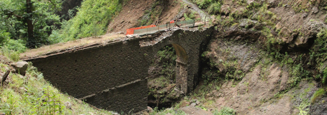
Pelo meio terás apenas um obstáculo:


No final da levada chegarás ao Ribeiro Bonito. Aqui poderás te sentar para um pequeno lanche rodeado por um verde imenso e onde apenas se ouve o som da água do ribeiro que desce lentamente por entre as rochas.
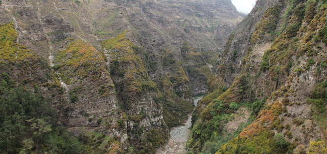
O Ribeiro Bonito, é um dos afluentes da grande Ribeira de São Jorge, que diga-se de passagem, é espectacular desde a sua cabeceira nas proximidades do Pico Ruivo, até à foz, encravada entre duas Achadas.
O Ribeiro Bonito é considerado um santuário natural devido à extrema beleza do local, coberto por vegetação que caracteriza uma das Florestas indígenas da Madeira, a mais densa e exuberante- a Floresta Laurissilva- atingindo o expoente máximo, pela sua localização, isolamento e abundância de água.

Sugestão: Alguns metros antes da madre da levada, sobe pelo discreto trilho à tua direita (ver foto) e sobe um pouco para usufruir de maior privacidade e de novas perspectivas para o Ribeiro Bonito.

O sinal GPS é geralmente fraco nesta área.


No regresso percorrerá o mesmo percurso podendo apreciar ainda mais calmamente as belezas da zona: a Ribeira de São Jorge com toda a sua rede de córregos e ribeiros; a povoação da Ilha; mais ao longe os lombos e achadas da freguesia de Santana; e finalmente o grande atlântico.  

Ao finalizar o trilho não deixe de visitar o Moinho De Água de São Jorge (coordenadas) com cerca de três séculos de história, sendo um bom exemplo de preservação, alimentado com as águas da Levada do Rei, que faz moer o trigo, o milho, a cevada e o centeio, cultivados em poios agrícolas de São Jorge.


EN:
Welcome to the forest of "São Jorge"!

Total Distance: 10.2 km
Highest point: 710m
Lowest point: 530m


This route starts next to the Water Treatment Plant at Quebradas in São Jorge.
Park your car at the following coordinates: N32º49.004, W16º55.484
Then you must climb the stairs to find the levada (coordinates: N32º48.922, W16º55.522)


The distance is 5.1km (Total: 10,2km) in a well-kept levada with protections in several areas. This tour is magnificent. Your entire route is surrounded by beautiful ferns of various species and its floor has a moss cover, which gives it a unique beauty, and the ceilings are made of the most beautiful crowns of Madeira laurels (Ocotea foetens), the laurel trees (Laurus novocanariensis) and the Madeira mahogany (Persea indica).

Your biggest obstacle will be to pass under a small waterfall (see picture). Take a raincoat.

At the end of levada you will arrive to Ribeiro Bonito. Here you may sit down for a snack surrounded by an immense green while listening to the sound of the water descending slowly through the rocks.

Ribeiro Bonito is one of the tributaries of the large Ribeira de São Jorge, which is spectacular from its head near Pico Ruivo, to the mouth, stuck between two mountains.

Ribeiro Bonito is a true sanctuary of nature. This is one of the areas of the Laurisilva forest - World Nature Heritage of UNESCO since 1999, where the genuinely Madeiran vegetation reaches its highest expression and its location and isolation leave one with the sensation of having gone back in time to the discovery of the island.

Tip: Some meters before the end of the levada go up using the discrete track on your right (see picture) and climb up a bit to enjoy a greater privacy and new sights of Ribeiro Bonito.

GPS signal is generally weak in this area.

When returning you will travel the same route calmly enjoying the area's beauty: Ribeira de São Jorge with its entire network of streams and rivers; the population of Ilha; farther away the hills and valleys of Santana; and finally the great Atlantic Ocean.

Be sure to visit the São Jorge water mill (moínho), which is about three hundred years old. This mill is a good example of preservation, and powered by the water from the Levada do Rei, it grinds wheat, maize, barley and rye grown on the terraces of São Jorge.


GPS: 


terça-feira, 1 de novembro de 2016

Quinta do Santo da Serra

Quinta do Santo da Serra
32° 43.453'N, 16° 49.098'W


PT:


A Quinta do Santo da Serra situa-se na freguesia de Santo António da Serra, Concelho de Machico.


A Quinta do Santo da Serra é um espaço de lazer e recreio bem conhecido, já visitado por grande parte dos madeirenses e muito utilizado pela população escolar infantil para desenvolver actividades lúdico desportivas. Constitui ainda um polo de atracção turística da freguesia de Santo António da Serra, frequentemente referenciado nos guias turísticos da Ilha.

Oferece:

☼ acesso grátis; 
☼ uma pequena exposição de animais, com especial relevância para a população de Gamos e três póneis que sem raça registada sabe-se serem resultantes de cruzamentos entre o pónei de Timor e o garrano do Gerês, aquando da tentativa de ser conseguido um pónei rústico para as serras da Madeira;
☼ observação de diferentes espécies arbóreas e arbustivas indígenas e exóticas;
☼ um mini-golfe;
☼ um campo de ténis;
☼ um miradouro sobre as serras do concelho de Machico, Ponta de São Lourenço e Ilha do Porto Santo;
☼ parque de merendas.
☼ aos domingos há uma feira por perto. (32° 43.532'N, 16° 49.230'W).


EN:
Quinta do Santo da Serra (Santo da Serra's Estate) is located in Santo António da Serra, Municipality of Machico.

Quinta Santo da Serra is a well-known place of leisure and recreation, already visited by most of the islanders and used by the children's school population to develop sports and recreational activities. It is also a tourist attraction of Santo António da Serra, often referred to in the island's tour guides.

It offers:

☼ free access;
☼ a small exhibition of animals, with particular relevance to the population of deers and three ponies without registered breed known to be the result of crossbreeding between ponys from Timor and Gerês, when attempting to create rustic pony for the mountains of Madeira;
☼ observation of different indigenous and exotic tree and shrub species;
☼ a mini-golf;
☼ a tennis court;
☼ a viewpoint to the mountains of Machico, Ponta de São Lourenço and Porto Santo;
☼ picnic area;
☼ every sunday there is a farmers market nearby (32° 43.532'N, 16° 49.230'W).


sexta-feira, 30 de setembro de 2016

Os benefícios da caminhada


terça-feira, 20 de setembro de 2016

Cais da Ponta do Sol

CAIS DA PONTA DO SOL32° 40.679'N, 17° 6.258'W


“O Século XIX foi, em vários aspectos, marcante na vida social do concelho da Ponta de Sol…. Depois de várias tentativas de melhorar o desembarque, a Câmara Municipal, auxiliada pelo trabalho braçal que os cabeças de casal eram obrigados a dar, construiu um cais. O Cais do Fojo foi, assim, uma autêntica dádiva para a evolução da Costa de Baixo. Em todo o lado, mesmo até no Funchal, os viajantes desembarcavam às costas dos barqueiros. Muitos deles eram homens sem escrúpulos e até com falta de educação. Nalguns casos, deixavam-se escorregar de trambolhão por cima das pedras, quando a carga que traziam ao ombro era do sexo feminino. Muitas senhoras detestavam viajar de barco para qualquer parte, porque não existia lugar cómodo para o desembarque. A Ponta de Sol passou a ter um cais em 1849, com o seu arco rasgando a paisagem como se fosse a entrada de um castelo de um conto de fadas…“


Segundo o projecto do engenheiro Tibério August Blanc foi mandado construir o tão ansiado cais, no ano de 1848, por iniciativa da Câmara Municipal.
A obra, que se arrastou por vários anos, foi baptizada de Duque Maximiliano de Leuchtenberg, pois é de crer que numa visita à Ponta do Sol este nobre ofereceu certa quantia para as despesas de construção do referido cais. Hoje em dia é mais conhecido como Cais do Fojo.
É de notar nesta obra o amplo, impressionante e bem concebido arco construído em aparelho de pedra basáltica à vista.
No início do cais podemos observar a antiga prisão escavada na rocha, agora transformada em restaurante, e a casa da guarda que lhe fica em frente.


Como não é novidade para ninguém, antes da haver as estradas de ligação entre os principais núcleos de povoamento, no século XIX e parte do XX, o principal meio de comunicação entre as vilas e o Funchal, e mesmo entre algumas localidades, era por via marítima, através dos vapores, cujo embarque e desembarque dos quais era feitos pelas lanchas, – termo então na origem do apelido Lancha/Lanchas, para nomear as pessoas do Funchal ou tão somente dai provenientes, que desembarcavam nas lanchas. A Ponta de Sol era nesses tempos o mais importante concelho da “Costa de Baixo” capitalizando um significativo conjunto de infraestruturas e serviços administrativos, comerciais e culturais que abrangiam toda uma circunscrição geográfica sul que incluía boa parte da actual Ribeira Brava.


Além de ter servido para o embarque e desembarque de pessoas e mercadorias em segurança, funcionou como troço do caminho real de ligação ao Lugar de Baixo que se rasgou na rocha posteriormente. É notável que apesar da voracidades das intempéries invernais, o cais chegou até aos nossos dias tornando-se um símbolo do próprio concelho e uma marca visível e venerável da arte de bem construir, cumprindo princípios técnicos de firmeza e utilidade aliados ao seu belo enquadramento com a paisagem ao seu redor.


PONTA DO SOL PIER

"The nineteenth century was, in many ways, remarkable in the social life of the Municipality of Ponta do Sol .... After several attempts to improve landing, the City Council, aided by the manual labor that the heads of family were forced to give, built a pier. Cais do Fojo was therefore a godsend for the evolution of the "Western Coast". Everywhere, even up in Funchal, travelers landed on the back of the boatmen. Many of them were unscrupulous men and even impolite. In some cases, they would let themselves slip over the rocks, when the load brought on their shoulders was female. Many ladies hated traveling by boat anywhere, because there was no convenient place for landing. Ponta do Sol started having a pier in 1849, with his bow ripping the landscape like the entrance of a fairy tale castle... "


The eagerly awaited pier was built according to the project engineer Tibérios August Blanc in the year 1848, by the initiative of the Municipality.
The work, which dragged on for several years, was baptized as Duke Maximilian of Leuchtenberg as it is believed that in a visit to Ponta do Sol this noble offered a certain amount for the cost of building this pier. Nowadays it is known as Cais do Fojo.
It is noted in this work the large, impressive and well-designed arch built with basaltic rock in sight. 
At the beginning of the pier we can observe the old prison carved into the rock, now converted into a restaurant, and the guardhouse that lies ahead.


As it is not news to anyone, before having the roads linking the major population centers, in the nineteenth and the twentieth centuries, the primary means of communication between the villages and Funchal, and even among some localities, was by sea through the vapors, whose embarkation and disembarkation was made ​​by "lanchas" (motor boats) - the term is then at the origin of the nickname "lanchas", to appoint people of Funchal or solely derived therefrom, which landed in "lanchas". Ponta do Sol was at this time the most important county of the "Western Coast" capitalizing on a significant set of infrastructures and administrative, commercial and cultural  services, covering an entire geographic south disctrict which included much of the current Ribeira Brava.

Apart from having served for the embarkation and disembarkation of passengers and goods safely, it worked as a section of the royal road connecting to Lugar de Baixo, that was later drilled on the rock. It is remarkable that despite the voracidades of wintry weather, the pier is still there becaming a symbol of the county itself and a visible and venerable mark of the art of building properly, fulfilling technical principles of firmness and utility allied to its beautiful environment with the landscape around it.

sexta-feira, 29 de abril de 2016

Rota da Água


Rota da água
Monte (Corujeira) - Pisão - Galerias dos Tornos Altos - Centro Temático da Água - Ribeira de Santa Luzia - Salto do Patagarro


Este percurso mostra-nos locais marcantes e históricos com incidência na importância da água.

É no Parque Ecológico do Funchal que se situa uma das grandes unidades geográficas responsáveis pela receptação, armazenamento e posterior distribuição de água: o planalto do Chão da Lagoa.

Efectivamente é neste local que se concentram e se infiltram as águas dos fortes caudais invernais, que brotam depois generosamente a cotas inferiores nas falésias que constituem a vertente esquerda da Ribeira de Santa Luzia e que genericamente se designam por nascentes dos Tornos Altos.

Sabiamente, e para fazer face à escassez de água na cidade do Funchal, desde tempos imemoriais que as nascentes dos Tornos Altos foram alvo de obras de captação e as suas águas conduzidas através de canais calcetados para o efeito. 
Com a chegada de novos e abundantes caudais de água à cidade do Funchal, provindos do norte da ilha, as nascentes dos Tornos Altos e os seus canais adutores foram caindo no esquecimento e votadas ao abandono, até aos dias de hoje.

Como homenagem e tributo aos homens de então que, arriscando muitas vezes a vida tão bem souberam apoderar-se das águas perdidas que brotavam das íngremes falésias, algumas acções de limpeza foram realizadas neste património edificado. 

A partir deste trilho centenário podem se observar paisagens estonteantes sobre o leito, profundamente encaixado, da Ribeira de Santa Luzia, mesmo às portas da cidade do Funchal
O percurso tem o seu início no Monte, no sítio da Corujeira. Através de um trilho significativamente largo, rapidamente chegamos à Ribeira do Pisão com a sua emblemática ponte e cascata, cujo caudal vai variando ao longo do ano. Aqui também podemos seguir a Levada dos Tornos, atravessando o túnel e seguindo a levada até Santa Cruz.


- Ponte do Pisão, localizada num dos afluentes da Ribeira de Santa Luzia – destruída parcialmente no temporal de 20 de fevereiro de 2010 e recuperada em 2016.
- Bridge of Pisão, located in one of the affluents of the Ribeira de Santa Luzia - partially destroyed in the storm of 20th February 2010 and recovered in 2016.

Logo após a travessia da ponte e ao chegar à levada, encontramos um discreto cruzamento onde para além da óbvia opção pela levada temos um percurso que sobe. A levada leva-nos em direcção ao Centro Temático da Água, já a subida conduz-nos até as nascentes e galerias dos Tornos Altos

Pouco antes das galerias e perto da sinalética em madeira "Nascente dos Tornos Altos", há uma subida íngreme que nos conduz até a Levada do Barreiro e a Casa do Barreiro.
Após uma visita sempre húmida às galerias, não é necessário efectuar todo o caminho de regresso. Há uma descida íngreme que faz uma ligação mais directa ao Centro Temático da Água.

O Centro Temático da Água está localizado junto à margem direita da Ribeira de Santa Luzia, onde foi construída, na década de 1970 e pelo valor de 3.600 contos, a Estação de Tratamento de Águas dos Tornos, estação que fez parte do sistema da levada dos Tornos até Maio de 2000, sendo até essa data a principal fonte de abastecimento de água ao concelho do Funchal. Inaugurada a 3 de agosto de 1977 esteve em funcionamento durante quase 23 anos, tendo sido desativada com a construção de uma nova infraestrutura, a Estação da Alegria, devido à necessidade de fazer face ao aumento da população do concelho do Funchal e ao maior rigor na recolha e no abastecimento de água.
Em 2009, a antiga estação foi transformada pela Câmara Municipal do Funchal num novo espaço, o Centro Temático da Água, com o objetivo de promover atividades pedagógicas e educação ambiental, tendo como foco principal a importância da água. Aqui o visitante (comunidade escolar e público em geral) tem oportunidade de reconstituir o percurso de abastecimento de água ao concelho do Funchal, e visitar o interior das quatro cisternas que constituem esta estação.
Se pretende visitar o Centro tenha atenção o seu horário de funcionamento: Segunda a sexta / 09h00-14h00 (ver aqui). Visite o sítio de internet do Centro Temático da Água aqui.


A Ribeira de Santa Luzia é uma das maiores do concelho do Funchal, caracterizada por apresentar vales profundos, rodeados de paredes escarpadas que podem atingir mais de 400 metros de altura. A nível de fauna constitui um importante reduto como área de nidificação da ave marinha, o Patagarro (Puffinus puffinus).

Os mais aventureiros poderão explorar a Ribeira de Santa Luzia subindo o seu leito por entre rochas de diferentes tamanhos e atravessando algumas vezes o seu caudal. Como recompensa e após 1,5 kms, temos uma imponente cascata com a particularidade de estar dividida em dois ressaltos, um com 60 metros e outro com 90 metros.

Na encosta este podemos ver as escadas que nos levam até ao topo da cascata e que nos oferecem outras 
possibilidades de percursos para os que querem enfrentar este desnível significativo.


ATENÇÃO: 

  • O acesso aos Tornos Altos possui algumas áreas degradadas e outras com muita água. 
  • Dentro da Ribeira de Santa Luzia não existe trilho. Deverás improvisar, tendo de atravessar várias vezes a ribeira. 
  • O local possui fraco sinal GPS. 
  • A dificuldade deste percurso depende do caudal da ribeira. Durante os meses de verão o acesso poderá ser mais simples mas a cascata poderá estar seca. Analisa as condições e não arrisques. 
  • O percurso deverá ser feito apenas com boas condições climatéricas. 
  • Deverás levar água e comida, roupa e calçado apropriados (roupa e calçado extra para o caso de te molhares). 
  • A utilização de um bordão é recomendada. 
  • Parking - Cascata - Parking: 9 km, 4h


This route shows us remarkable and historic sites with a focus on the importance of water.

It is in the Funchal Ecological Park that lies one of the major geographical units responsible for receiving, storing and subsequent distribution of water: the Chão da Lagoa plateau.

Indeed it is in this place that the waters of the strong winter flows gather and infiltrate, which spring later generously to lower levels in the cliffs that form the left side of the Ribeira de Santa Luzia and broadly are designated by springs of Tornos Altos.

Wisely, and to address the water shortage in the city of Funchal,  the sources of Tornos Altos were, since ancient times, subjected to catchment works and its water conducted through cobbled channels for this purpose.


With the arrival of new and abundant water flows to the city of Funchal from the north of the island, the sources of Tornos Altos and their channels were falling by the wayside and being ostracized until the present day.

As homage and tribute to the men that, often risking life, so well knew how to seize the lost water springing from the steep cliffs, cleaning actions were carried out in this built heritage.

From this centenary path we can observe stunning landscapes over the riverbed, deeply and tightly fitted, of Ribeira de Santa Luzia, close to Funchal city gates.


This route starts in Monte, at Corujeira. Through a significantly broad track, we quickly arrive at Ribeira do Pisão with its emblematic bridge and waterfall, whose flow rate will vary throughout the year. Here we can also follow the Levada dos Tornos through the tunnel and go all the way to Santa Cruz.

Soon after crossing the bridge and reaching the Levada, we encounter a discreet intersection where beyond the obvious Levada we have a path that goes up. The Levada to the left leads us towards the Centro Temático da Água (Water Theme Center), while the ascent takes us to the springs and galleries of Tornos Altos.

Just before the galleries and near the wooden sign "Nascente dos Tornos Altos", there is a steep climb that leads to the Levada do Barreiro and Casa do Barreiro.

After a moist visit to the galleries, it is not necessary to walk all the way back. Halfway through the descent, there is another steep descent which makes a direct connection to the Centro Temático da Água.


Centro Temático da Água is located near the right margin of the Ribeira de Santa Luzia where the Tornos Water Treatment Station was built in the 1970s. It was part of the Levada dos Tornos system until May 2000 and constituted until then the main source of water supply to the municipality of Funchal. Inaugurated on August 3, 1977, it operated for almost 23 years when it was disabled due to the construction of a new infrastructure, the Alegria Station, justifyed by the needs of the growing population of Funchal and the more rigorous collection and supply of water.

In 2009 the old water station was transformed by the Municipality of Funchal in a new space, the Water Theme Center (Centro Temático da Água), in order to promote educational activities and environmental education focused mainly in the importance of water. Here the visitor (the school community and general public) has the opportunity to reconstruct the route of water supply to the municipality of Funchal, and visit the interior of the four tanks that make up this station.

If you wish to visit the centre take into account its opening hours: Monday-Friday / 09h00-14h00 (view here). Visit the Centro Temático da Água website here.


The Ribeira de Santa Luzia is one of the largest of Funchal and is characterized by deep valleys surrounded by steep walls that can reach over 400 feet tall. In terms of wildlife is an important nesting area of a seabird, the Manx Shearwaters (Puffinus puffinus).

The more adventurous can explore the Ribeira de Santa Luzia going up its riverbed between rocks of different sizes and sometimes crossing its flow. As a reward, and after 1,5kms, we have an impressive waterfall with the particularity of being divided into two rebounds, one with 60 meters and the other with 90 meters.
In the east slope we can see the stairs that guides us to the top of the waterfall and offering other route possibilities for those who want to face this significant slope.

ATTENTION:
  • The access to Tornos Altos has some degraded areas and others with plenty of water. 
  • Inside Ribeira de Santa Luzia there is no trail. You have to improvise, having to cross the river several times. 
  • The location has weak GPS signal. 
  • The difficulty of this trail depends on the flow of the stream. During the summer months access may be simpler but the waterfall may be dry. Analyze the conditions and don't take risks. 
  • The course must be done only with good weather conditions. 
  • You should bring water, food, clothing and appropriate footwear (extra clothing in case you get wet). 
  • The use of walking poles is recommended. 
  • Parking - Waterfall - Parking: 9 km, 4h


GPS:


domingo, 3 de abril de 2016

Madeira Digital Magazine - April 2016

Madeira Digital Magazine - April 2016

It was a great pleasure to be invited to share some of my photos do the Madeira Digital Magazine for its latest edition (april 2016).
Madeira Digital is a monthly publication, digital and of free subscription, that aims to provide, through text and image, a broad approach to the most important and significant regional events in all areas of interest (economy, politic, society, culture, sports, fashion, entertainment, technologies, tourism and photography).


Original text:
Landscapes
Photography, essentially landscape photography, is a result of my passion for the trails and secrets of our island. Amateur and self-taught, I intend to increase my knowledge in order to share in the best way what my eyes encounter in the nooks and crannies of Madeira. I am fortunate to occasionally practice canyoning, an activity that gives me access to magnificent scenery.

You can see more photos on the following sites:

quinta-feira, 10 de março de 2016

Cascata do Véu da Noiva - Porto Moniz

Véu da Noiva
32° 48.966'N, 17° 5.716'W


PT:
O Miradouro do Véu da Noiva na antiga estrada que liga São Vicente ao Seixal, no concelho do Porto Moniz, deve o seu nome à queda de água que se precipita com grande força formando espuma, fazendo lembrar um véu branco.
O Véu da Noiva é uma paisagem emblemática da Madeira e é a parte visível da Ribeira do João Delgado cujo curso de água desce pela montanha desde o Paúl da Serra, desenhando e esculpindo magníficas paisagens de extrema beleza natural.

Fast Descent Canyoning Team in The Bride's Veil

EN:
Véu da Noiva (The Bride's Veil) viewpoint in an ancient road linking São Vicente and Seixal, in Porto Moniz, takes its name from the waterfall that rushes with great force forming foam, resembling a white veil.
Véu da Noiva is an emblematic landscape of Madeira and is the visible part of the João Delgado River whose watercourse runs down the mountain from Paúl da Serra, drawing and sculpting magnificent landscapes of great natural beauty.
Algumas fotos antigas / Some old pictures:

Véu da Noiva
...

quarta-feira, 9 de março de 2016

Poço do Candeeiro - Chão da Ribeira

Poço do Candeeiro - Chão da Ribeira
32° 48.634'N, 17° 6.944'W


PT:
O Poço do Candeeiro é uma pequena lagoa e cascata situada no Chão da Ribeira e é um dos bonitos segredos que a Ribeira do Seixal tem para nos oferecer. 
A cascata tem geralmente um caudal muito fraco fruto da captação da água em níveis superiores. 
Para aceder a este local terás de subir um pouco dentro do leito da ribeira. 
A água é quase inexistente e as pedras são geralmente pequenas, sendo este um percurso acessível e seguro. 


EN:
Poço do Candeeiro is a small pond and waterfall located in Chão da Ribeira and is one of the beautiful secrets that Ribeira do Seixal has to offer.
The waterfall usually has a very low flow due to water catchment at higher levels.
To access this site you must climb a bit within the stream bed.
The water is almost nonexistent and the stones are usually small, making this an easy and safe route.


VIDEO:

...

GPS:


sexta-feira, 26 de fevereiro de 2016

Levada do Brasileiro - Porto Moniz


PT:
O vale da Ribeira da Janela é rico em beleza e em pequeno cursos de água que alimentam a sua ribeira. 
Como habitual muita dessa água é canalizada para levadas que fazem as delícias de quem nos visita. 
Levada da Ribeira da Janela é das mais conhecidas da área e é frequentemente visitada mas a uma altitude superior e com uma extensão inferior podemos encontrar uma levada interessante que é do conhecimento de poucos - A Levada do Brasileiro
Levada do Brasileiro têm o seu início num túnel de captação cuja entrada está fechada. A levada tem a particularidade de conduzir a água através de diferentes níveis, deixando a água correr livremente do nível superior até que volta a ser captada pelo nível inferior como se de uma escada se tratasse.
A levada termina conduzindo a água até a Lagoa do Bardo. É aqui que iniciamos o percurso realizando o caminho inverso da água.


A levada possui três níveis. As subidas de um nível para o outro não estão assinaladas. Utiliza o curso de água como guia, procurando as subidas logo após as zonas de captação de água que cai de níveis superiores.
No final encontrarás uma subida que te irá conduzir até a estrada regional. Poderás optar por regressar pela estrada ou voltar pelo mesmo caminho.


ATENÇÃO
- O percurso deverá ser feito apenas com boas condições climatéricas.
- Deverás levar água e comida, roupa e calçado apropriados.
- Carro - Madre da Levada - Carro: 6 km, 2h, 180m de desnível.
- Percurso sem protecções. Não aconselhado a pessoas com vertigens.
- A Levada do Brasileiro pode ser feita juntamente com a Levada do Moinho 


EN:
The valley of Ribeira da Janela is rich in beauty and small waterways that feed its stream.
As usual much of that water is channeled into Levadas to the delight of those who visit us.
The Levada da Ribeira da Janela is the best known of the area and is often visited but at a higher altitude and with a lower extent we may find an interesting Levada that is unknown by many - Levada do Brasileiro.
Levada do Brasileiro has its beginning in a catchment tunnel whose entrance is closed. The Levada has the particularity of leading the water through different levels, letting the water run freely from the top level until it is again captured by the lower level as if it were a staircase.
The Levada ends leading the water into a pond - Lagoa do Bardo. This is where we start the route making the reverse path of the water.


The Levada has three levels. The climbs from one level to the other are not marked. Use the watercourse as a guide, looking for the detour a few meters after catchment areas of water falling from higher levels.
At the end you will find a climb that will lead you to the regional road. You can choose to return using that road or back the same way.

ATTENTION
- The course must be done with good weather conditions.
- You should bring food and water, appropriate clothing and footwear.
- Car - End - Car: 6 km, 2h, 180m gradient
- Route without guard-rails. Not suitable for people with vertigo.
- You can do Levada do Brasileiro and Levada do Moinho in a single circular route.


GPS:


The best places to stay in Madeira

Feel like a local, find great places to stay and win a bonus for your first visit!

Ajuda a nossa página / Help us maintain this page

Related Posts Plugin for WordPress, Blogger...

Videos

Activities in Madeira